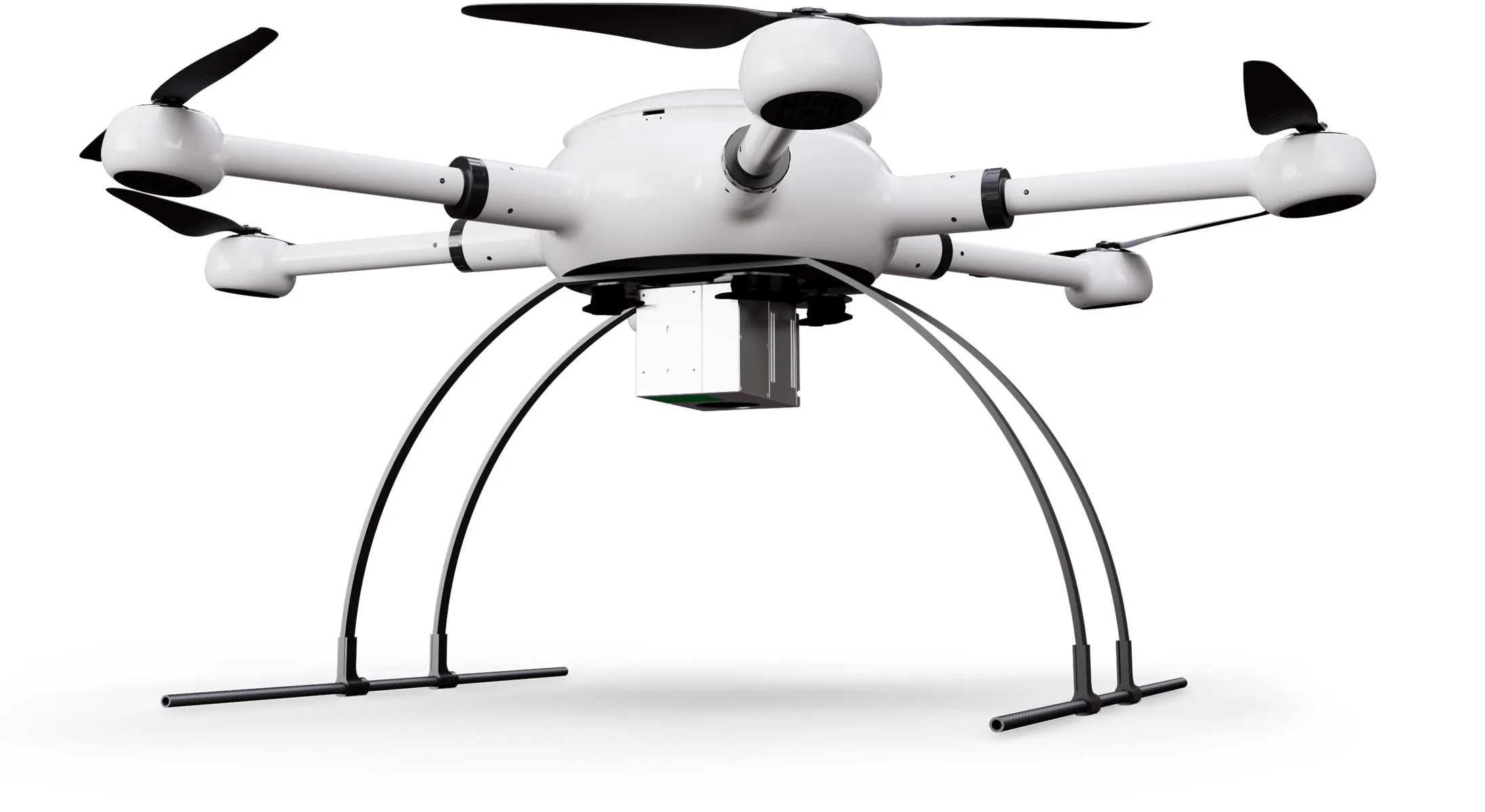
Mercury LiDAR
Highlights Technical data
Request price
Icon: Weight
3,5 kg
max payload
Icon: Stopwatch
20 min
Flight time
Icon: Photo and magnifying glass
< 2 cm
Accuracy
Icon: LiDAR scan range
450 m
LiDAR range
Mercury LiDAR

Look at: 3D point clouds in real colors

The scanner from the Mercury LiDAR package offers an accuracy of < 2 cm and also delivers color images thanks to the integrated 42 MP camera, so that the point clouds can be combined with the photos to create a colorized 3D display with real colors. The results are impressive.

Agile and efficient

The Mercury drone has a payload of up to 3.5 kg and delivers very respectable results with the combination of scanner and camera. Per battery and depending on weather conditions, the drone can stay in the air for up to 20 minutes and operate at altitudes of up to 5,000 meters above sea level. For your projects, this surveying solution is ideally suited.

Icon: Stopwatch
20 min
Flight time
5.000 m
Flight altitude
Vast landscape, through which a path winds, in the sunset.

Simple and intuitive flight planning

Flight planning made easy: Set the framework for your survey project on your PC or on the remote control screen and your drone will perform the flight automatically. If desired, you can intervene in the control via the EB controllers and steer by hand.

Icon: Waypoint for mission planning
PC+RC
Flight planning
Icon: automated drone flight
AutoFlight
Automatic missions
Aerial view of a forest area with waypoints for automated drone flight.

Handy and robust remote control

With the portable EB controller with a high-resolution 5.5 inch monitor, you always have full flight control. A range of up to 4 kilometers gives you plenty of scope, just like the built-in 4950 mAh lithium polymer battery for up to 5 hours of runtime.

Icon: Display size
5.5 inch
RC display
Icon: Battery being charged
5 h
Battery life
Exabotix employee controls drone in the distance over a pipeline running through an uninhabited landscape.

LiPo power for enduring missions

The powerful flight battery provides good endurance and excellent flight performance. With 22,000 mAh and 22.2 volts, it is a real powerhouse. The battery is located inside, so it is protected from the weather, can be replaced in a few simple steps and fully recharged in just 45 minutes.

Icon: Battery, three quarters full
22.000
mAh capacity
Icon: Stopwatch
45 min
Loading time

For which applications is this package suitable?

Want to combine the scanner's precise point clouds with real-color photos? This LiDAR package shines with an integrated 24 MP camera, ensuring accurate results that look good. This combination is versatile and with the powerful Mercury drone you stay flexible - even for other payloads.

Exabotix Mercury LiDAR Industrial drone front view with LiDAR scanner for precise 3D scanning.

Surveying

Cartography

Corridor mapping

Mining

Structural and civil engineering

Volume calculation

Mercury LiDAR Components

Icon: Hexacopter
Hexacopter
The Mercury drone has six drive units and a sturdy housing. The drone is compactly stowable for transport, its separate arms are simply plugged in, so it is quickly ready for use. With up to 3.5 kg payload, it offers enough capacity even for heavy payloads.
Icon: Battery, three quarters full
Battery
A powerful LiPo flight battery with 22,000 mAh provides plenty of power for enduring missions. The battery can be replaced in just a few steps, so even extensive surveying projects can be carried out without any problems.
Icon: Battery being charged
Charger
This fast charger lives up to its name: Two batteries can be fully charged simultaneously within 45 minutes.
Icon: Transport box
Transport box
In the robust and impact-resistant transport box, the drone system is well protected and practical to transport at any time.
LiDAR scanner
The EB-LiDAR scanning unit with 720,000 p/sec (Triple Echo) offers an accuracy of up to 2 cm at a maximum flight altitude of 100 meters, supported by a dedicated GNSS and IMU unit. Thanks to the integrated 24 MP camera, precise point clouds can be generated in real colors.
Icon: two circular arrows rotating counterclockwise around a circle.
Postprocessing
The post-processing software is part of the Exabotix performance package and allows to convert the raw data from the scanner into different point cloud data formats as well as to perform colorization based on the camera RGB data.
RTK multiband
The system achieves very high accuracy: via a multiband RTK-GNSS receiver, the collected position data is corrected and provides high precision with deviations in the millimeter range.
Remote control
The portable EB controller has a large display and enables intuitive route planning and operation via touchscreen and also has physical controls for hand control. The robust workmanship and its long battery life make the EB Controller a reliable work tool.

Cost?

This package smartly combines precise LiDAR scanning technology with the real colors of the integrated camera. You get handsome results that meet high demands. That's why the Mercury LiDAR is your flexible tool for many surveying tasks. We will be happy to explain the advantages of this package to you individually - just contact us.