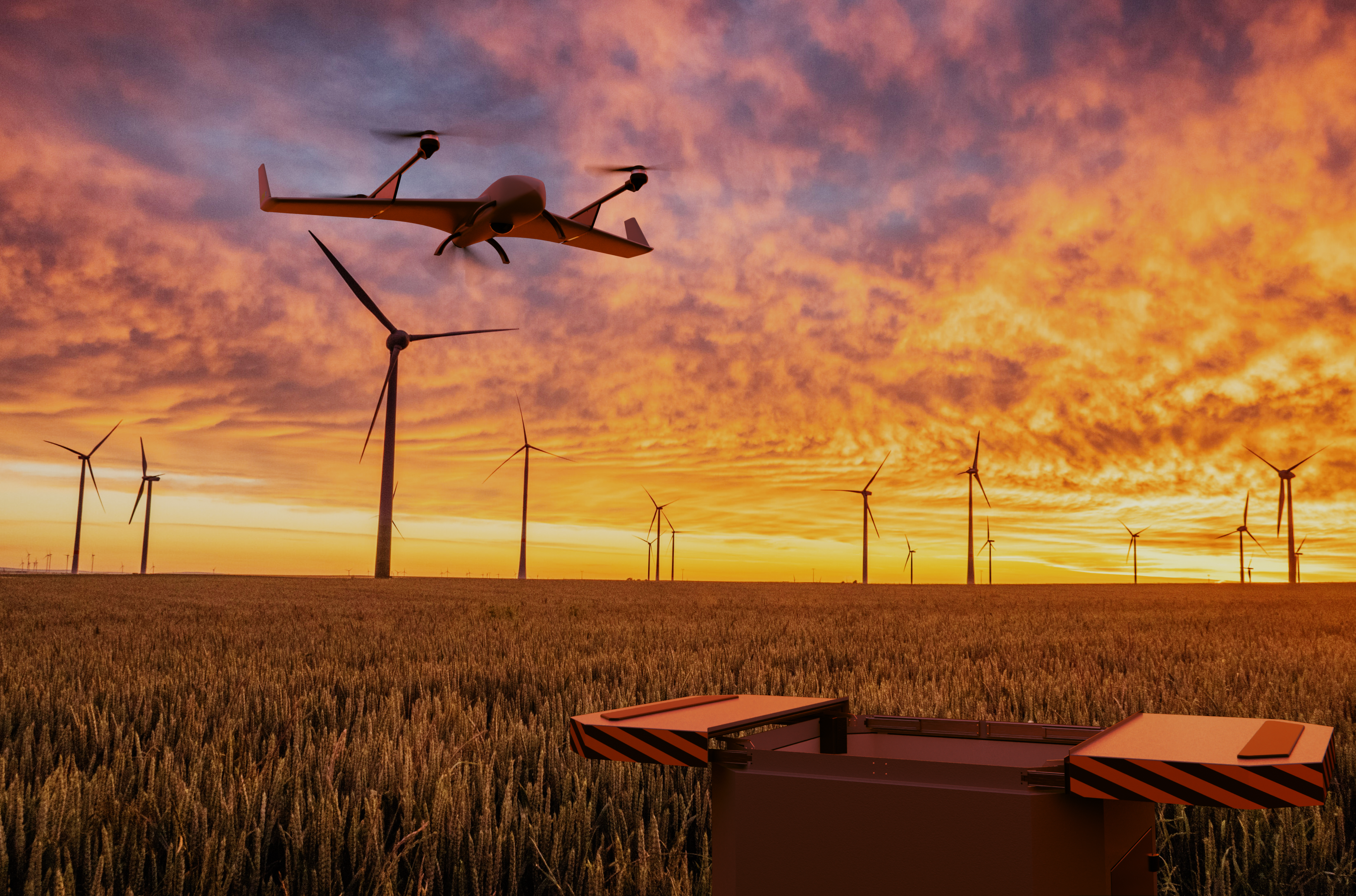
Effizientere Inspektionen von kritischer Infrastruktur.
Dauerhaft genehmigte BVLOS Drohnenoperationen.
Made in Germany mit EU-Datenschutz.
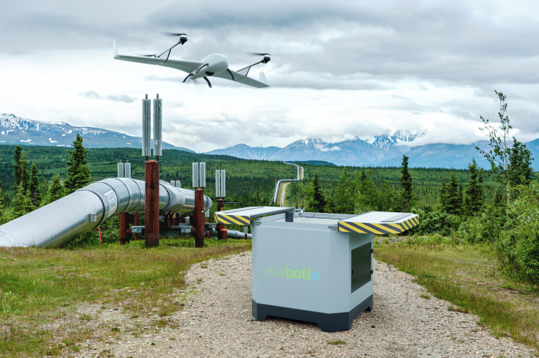
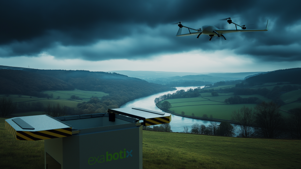
VTOL-in-a-Box.
100 km Flüge ohne Pilot.
› Effizientere Inspektionen und Überwachung
› Engmaschigere Kontrollen für höhere Versorgungssicherheit
› KI-gestützte Auswertung der Bilddaten
› Nachhaltiger und umweltschonender als Helikoptereinsätze
› Betrieb, Flugplanung und Wartung als Service
› Kein Fernpilot vor Ort nötig durch Vorflugkontrollsystem
Entwickelt in Niedersachsen. Datenschutz nach DSGVO.
Exabotix ist seit 2015 Experte im Bereich der Industriedrohnen.
Mit der Entwicklung des DRONEPORTS machen wir Drohnenflüge vollständig autonom und damit unabhängig vom Menschen.
Höchster Datenschutzstandard für sicherheitsrelevante Bereiche nach National Defence Authorization Act und DSGVO. Mit lokaler Speicherung der Bilddaten auf Servern in Deutschland.
TECHNISCHE DATEN DRONEPORT
› 1500 x 1500 x 1500 mm, 350 kg
› Wärmegedämmtes Gehäuse
› Integriertes Vorflugkontrollsystem
› Automatische Ladung des Flugakkus
› Stromversorgung: 230V/16A
› 5G-/LTE-/LAN-Einbindung Netzwerk, WLAN
› Integrierter Akku für Notstrom
› Alternativ autarker Betrieb möglich
› Integrierte Wetterstation
› Integrierte Klimaanlage
› Optionales Autarkpaket
› Optionale Warnanlage
AUF EINEN BLICK
Genehmigt und startklar
Genehmigungsfähig nach EU-Drohnenverordnung.
Industrielles Design
Kompakt, robust und einbruchsicher. Auch unter extremen Einflüssen.
Kosteneffizienz
Reduzierung von Inspektionskosten durch automatisierte Flugmissionen.
Datenschutz
Höchster Datenschutzstandard nach National Defense Authorization Act.
Nahtlose Zusammenarbeit
Drohne, Hangar und Software -
garantierte Kompatibilität.
Betriebssicherheit
Frühzeitige Anomaliedetektion zur Vermeidung von Fehlerkosten und Folgeschäden.
Maximale Flugdistanz
Kompaktes System für VTOL und Multicopter.
Gefertigt in Deutschland
Höchste Qualitätsstandards und stabile Lieferketten.
KOMPATIBLE DROHNENSYSTEME
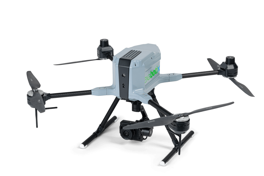
HELIOS
Der HELIOS Multicopter ist eine hochmoderne Drohne der neuesten Generation, entwickelt für anspruchsvolle industrielle Anwendungen.
Dank seines leistungsstarken Antriebssystems und optimierten Energiemanagements überzeugt der HELIOS mit beeindruckenden Flugzeiten und stabiler Performance – auch unter anspruchsvollen Bedingungen.
Robust, zuverlässig und vielseitig einsetzbar – HELIOS ist die ideale Lösung für Inspektionen, Überwachung, Vermessungen und viele weitere professionelle Anwendungen.
- Flugzeit: ca. 50 Minuten
- Payload: 2,5 kg
- Schutzart: IP 54
- Akku mit Schnelladefunktion
- Integriertes 5G/LTE Modul
- Integriertes Fallschirmsystem
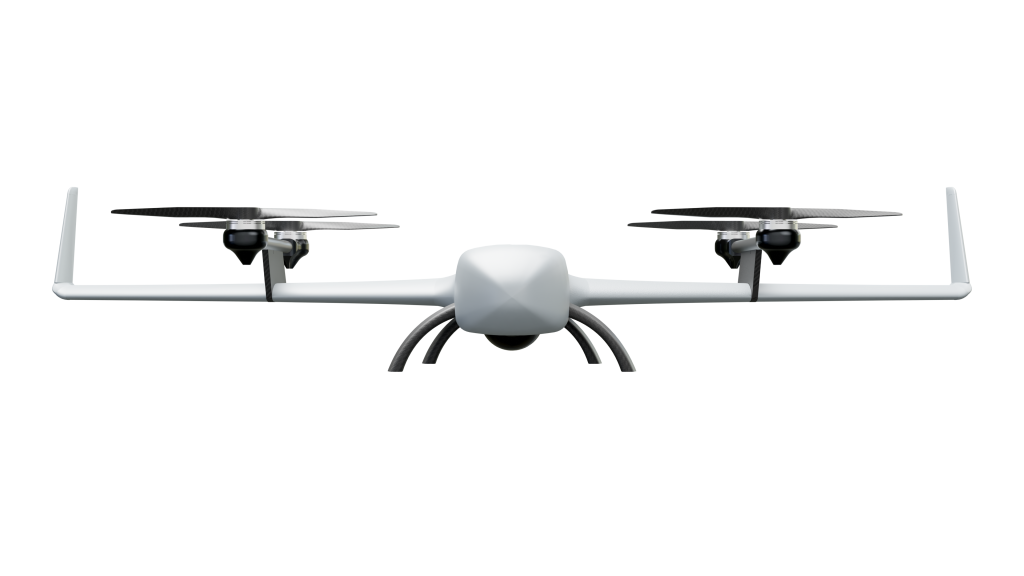
SWIFT VTOL
Der SWIFT VTOL kombiniert senkrechten Start mit effizientem Langstreckenflug von bis zu 90 Minuten und eine Distanz von 100 km. Robustes Design sorgt für zuverlässige Einsätze, selbst unter anspruchsvollen Bedingungen.
- Flugzeit: ca. 90 Minuten
- Payload: 500 g
- Flugdistanz: ca. 100 km
- Schutzart: IP 54
- Integriertes 5G/LTE Modul
- Integriertes Fallschirmsystem
PAYLOAD
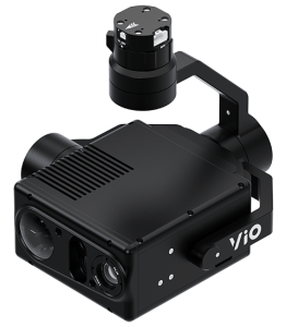
GREMSY VIO Gimbal
› Gewicht: 854g (1.88 lbs)
› Abmessungen: 173 x 148 x 159 mm
› Kamera/Wärmebildkamera/Laserscanner
› Kamera: 4K@30fps 30x Zoom
› Wärmebild: 8xZoom, 640×512@60Hz
› Laserscanner: 0-2400m (1Hz), 0-1200m (10Hz), Präzision: 0,1m-0,5m
› Object Tracking (Vision/Thermal Camera)
› Frame Rate: 30 fps
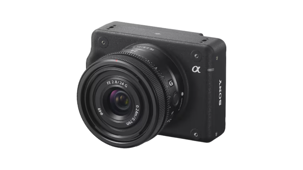
Sony ILX-LR1
› Gewicht: 243 g
› Abmessungen: 100 x 74 x 42,5 mm
› Auflösung: 61,0 Megapixel
› Lichtempfindlichkeit: ISO 100–32.000
› Serienbild: 3 Bilder/s
› Sensor: 35 mm Vollformatsensor
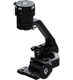
Gremsy Pixy LR
› Gewicht: 495g (1 lbs)
› Abmessungen: 140 x 115 x 200 mm
› Betriebstemperatur: 0° C ~ 50° C
› Unterstützte Kamera: Sony ILX-LR1
› Betriebsmodi: ON/OFF, Lock mode, Follow mode / Mapping mode
SOFTWARE
Kontrollzentrum und
KI Datenauswertung
Von der Missionsplanung bis hin zur Echtzeitüberwachung ist unser DRONEPORT darauf ausgelegt, Ihre Ressourcen zu entlasten. Sie greifen nur dann auf die Daten zu, wenn die Auswertung des Bildmaterials mittels KI eine Anomalie meldet. So werden Ihre Inspektionsprozesse engmaschiger und zugleich effizienter. Damit setzen Sie Kapazitäten frei, um sich auf die Versorgungssicherheit zu konzentrieren.
Servicedienstleistungen
Die gesamte Planung, Bearbeitung und Überwachung der Flugrouten kann in unserem System erfolgen. Notlandepunkte, individuelle Fly-to-Aufgaben und flexible Anpassungen an wechselnde Bedingungen werden zentral in unserer Software gesteuert. Auf Wunsch bieten wir die Datenauswertung auch als Servicepaket an.
FAQ
Automatisierte Drohnenflüge sind äußerst sicher. Unsere Systeme sind so programmiert, dass sie auf verschiedenste Szenarien vorbereitet sind. Im Falle von Schwierigkeiten oder technischen Problemen wurden sichere Notfallprotokolle implementiert, die eine kontrollierte Landung gewährleisten, sodass Betriebssicherheit und Schutz jederzeit priorisiert werden.
Die Fluggenehmigungen werden einmalig für jede Flugstrecke ausgestellt, sodass keine separate Aufstiegsgenehmigung für jeden Flug mehr nötig ist. Stattdessen erhalten Sie eine Betriebsgenehmigung für wiederkehrende Einsätze. Für unser System sind keine Einzelflug-Genehmigungen erforderlich.
Die Wartungskosten sind durch unser Servicepaket abgedeckt, wodurch die Betriebskosten klar kalkulierbar bleiben. Wir empfehlen eine jährliche Inspektion, die von unserem Service-Team durchgeführt wird, um eine reibungslose Funktionsweise und Betriebssicherheit zu gewährleisten.
Der DRONEPORT benötigt nur minimale Infrastruktur: ebener und fester Untergrund, einen Stromanschluss und eine Datenverbindung sind ausreichend. Alternativ lassen sich Solarzellen für einen autarken betrieb unabhängig vom Stromnetz installieren. Die Datenübertragung erfolgt standardmäßig über Mobilfunk, was den Betrieb auch in abgelegenen Gebieten ermöglicht. In Einzelfällen bieten wir alternative Optionen zur Datenübertragung an. Unser Installationsteam übernimmt die gesamte Einrichtung und schult Ihre Mitarbeiter, sodass das System direkt einsatzbereit ist.
Das System ist robust und für den Einsatz bei verschiedensten Wetterbedingungen ausgelegt. Sowohl Drohnen als auch Hangar sind gegen extreme Wetterlagen geschützt, was den Einsatz ganzjährig möglich macht.
Ja, Drohnenflüge in Flugverbotszonen sind mit unserem System möglich. Die Genehmigung kann durch den jeweiligen Betreiber oder Verwalter der Flugverbotszone erteilt werden. Unser Team unterstützt Sie dabei, alle notwendigen Genehmigungen zu erhalten.
Eine permanente Datenverbindung ist nicht zwingend erforderlich, um den Flug sicher fortzusetzen. Falls die Verbindung abreißt und eine kritische Situation entsteht, kehrt die Drohne automatisch zu ihrem Hangar zurück. Sollte der Hangar nicht erreichbar sein, landet sie an einem vorher definierten Notfalllandepunkt, der genau für solche Situationen vorgesehen ist.
Das DRONEPORT System wird von Exabotix in Deutschland hergestellt.
Das System ist ab Frühjahr 2025 zum Kauf verfügbar. Alternativ bieten wir Mietmodelle an. Sprechen Sie uns an.