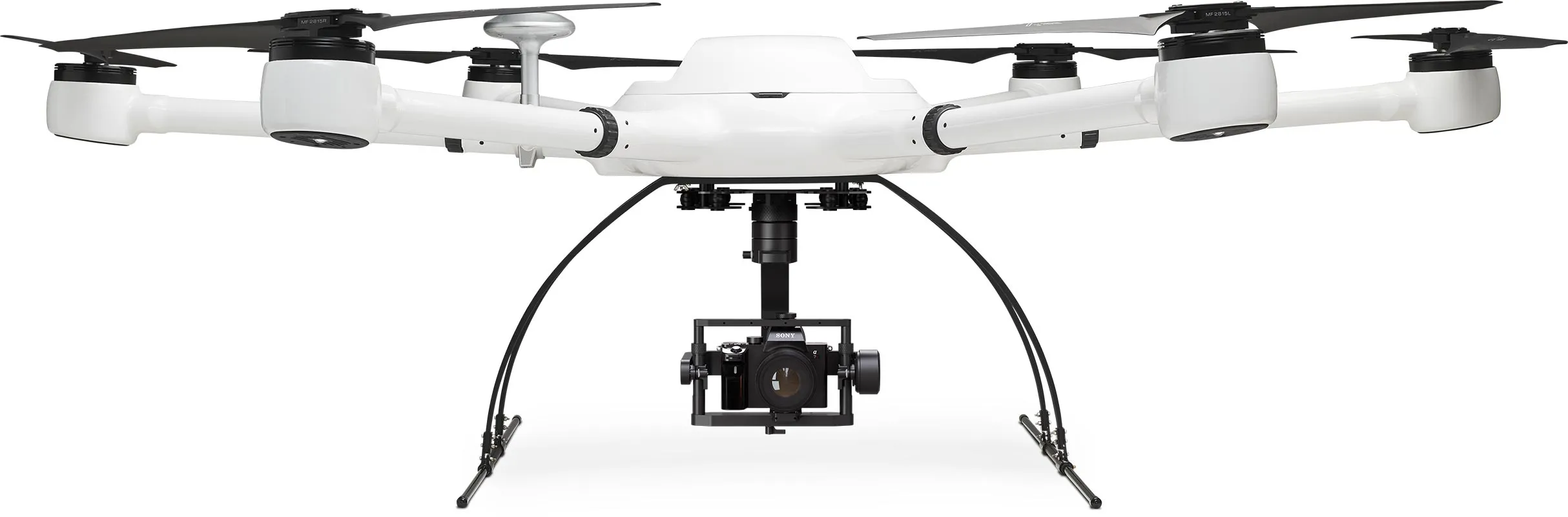
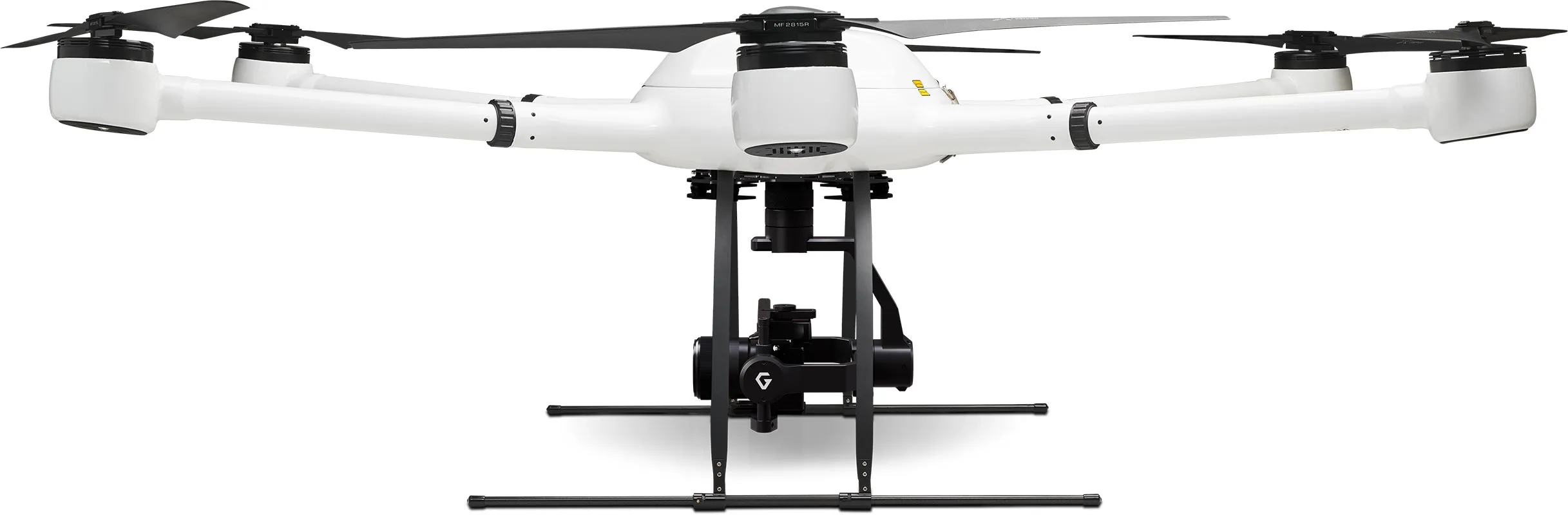
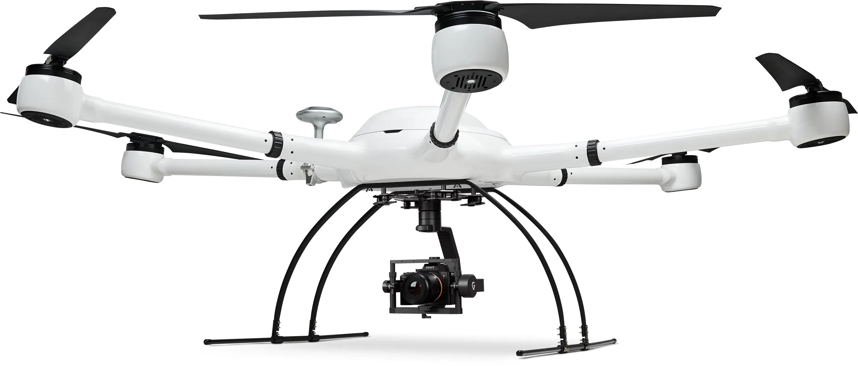
Icon: Weight
13 kg
max payload
Icon: Width
200 cm
Span
Icon: Photo and magnifying glass
< 1 cm
Accuracy
Icon: Digialization
61 MP
Image resolution
Atlas Mapper

The big solution for big tasks

A payload of up to 13 kg and more than 2 m wingspan show who is the boss here. This drone package offers you a lot of payload, a stable flight position and a very good camera resolution with interchangeable lenses. The hexacopter is quickly assembled thanks to a simple plug-in system. This package leaves nothing to be desired to solve your tasks professionally.

High resolution and plenty of optical freedom of movement

An advanced 3-axis camera gimbal and a 61 MP camera with interchangeable lenses make this package so powerful. With the power of two batteries, you can stay in the air for up to 25 minutes, depending on the weather. Thanks to the flexibility in viewing angle, the system is suitable for 2D and 3D photogrammetry and can also be used for inspection and surveillance tasks.

Icon: Digialization
61 MP
Resolution
Icon: XYZ-3 axes
3
Gimbal axes
Vast landscape, through which a path winds, in the sunset.

Simple and intuitive flight planning

Flight planning made easy: Set the framework for your survey project on your PC or on the remote control screen and your drone will perform the flight automatically. If desired, you can intervene in the control via the EB controllers and steer by hand.

Icon: Waypoint for mission planning
PC+RC
Flight planning
Icon: automated drone flight
AutoFlight
Automatic missions
Aerial view of a forest area with waypoints for automated drone flight.

Handy and robust remote control

With the portable EB controller with a high-resolution 5.5 inch monitor, you always have full flight control. A range of up to 4 kilometers gives you plenty of scope, just like the built-in 4950 mAh lithium polymer battery for up to 5 hours of runtime.

Icon: Display size
5.5 inch
RC display
Icon: Battery being charged
5 h
Battery life
Exabotix employee controls drone in the distance over a pipeline running through an uninhabited landscape.

LiPo power for enduring missions

Two powerful flight batteries provide good endurance and excellent flight performance. With 22,000 mAh and 22.2 volts, they are real power packs. The batteries are located inside, so they are protected from the weather, can be replaced in a few simple steps and are fully recharged in just 45 minutes.

Icon: Battery, three quarters full
22K
mAh capacity
Icon: Stopwatch
45 min
Loading time
Exabotix Atlas drone with heavy gas sensor during an inspection flight over an area covered with a tarp in a wooded area.

For which applications is this package suitable?

You have big plans and need outstanding image resolution? This package features a 61MP interchangeable lens camera with full-frame sensor that delivers sharp, detailed images with precise positioning thanks to the multiband RTK-GNSS receiver. With the high-quality gimbal, you determine the desired camera angle and stabilize the camera for blur-free images - in addition to the stable flight position of the Atlas drone.

Exabotix Atlas Mapper Industrial drone front view with camera and gimbal for surveying and photogrammetry tasks.

Surveying

Cartography

Corridor mapping

Mining

Structural and civil engineering

Volume calculation

3D photogrammetry

Inspection tasks

Monitoring tasks

Atlas Mapper Components

Icon: Hexacopter
Hexacopter
The Atlas drone has six drive units and a very sturdy housing. The drone is compactly stowable for transport, its separate arms are simply plugged in, so it is quickly ready for use. With up to 13 kg payload, it offers enough capacity even for quite heavy payloads.
Icon: Battery, three quarters full
Battery
Two powerful LiPo flight batteries with 22,000 mAh each provide plenty of power for enduring missions. The batteries can be replaced in just a few steps, so even extensive surveying projects can be carried out without any problems.
Icon: Battery being charged
Charger
This fast charger lives up to its name: Two batteries can be fully charged simultaneously within 45 minutes.
Icon: Transport box
Transport box
In the robust and impact-resistant transport box, the drone system is well protected and practical to transport at any time.
Icon: Digialization
61 MP camera
The Sony A7R IV is a professional camera with a full-frame sensor. You can use various lenses via the Sony E-mount system. The camera is powered via the drone.
Icon: XYZ-3 axes
Gimbal
The Gremsy T3 Gimbal is a very advanced 3-axis gimbal used for demanding professional tasks. It offers many connections and functionalities and is ready for use within 2 seconds by plug & play installation.
Icon: Waypoint for mission planning
Image coordinates
During the flight, the exact geo-coordinates are assigned to each captured image and stored in the Exif metadata of the image. After the flight, the georeferenced data is directly available for further processing - without time-consuming matching.
Icon: Photo and magnifying glass
High accuracy
The system achieves very high accuracy: via a multiband RTK-GNSS receiver, the collected data is corrected and provides high precision with deviations in the millimeter range.

Cost?

This package is for demanding users who are looking for a lot of flexibility at a fair price: The drone with an appealing payload, a 3-axis gimbal, the powerful camera and intuitive project planning, as well as easy further processing of the highly accurate data. The Atlas Mapper is your professional tool for surveying tasks and more. We will be happy to explain the advantages of this package to you individually - just contact us.