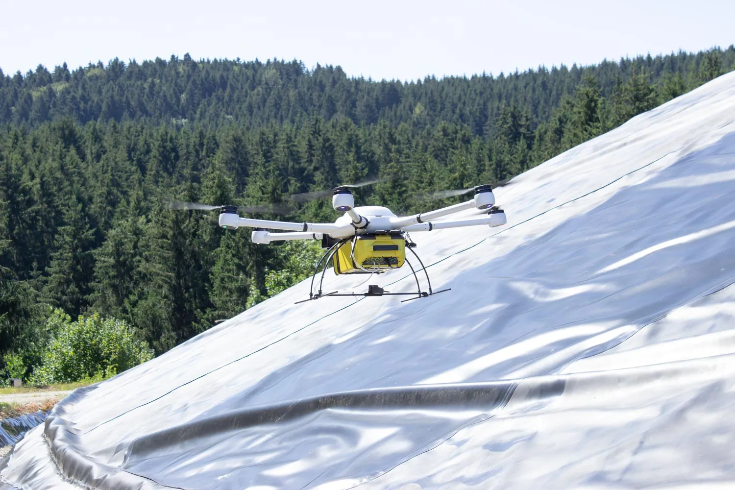
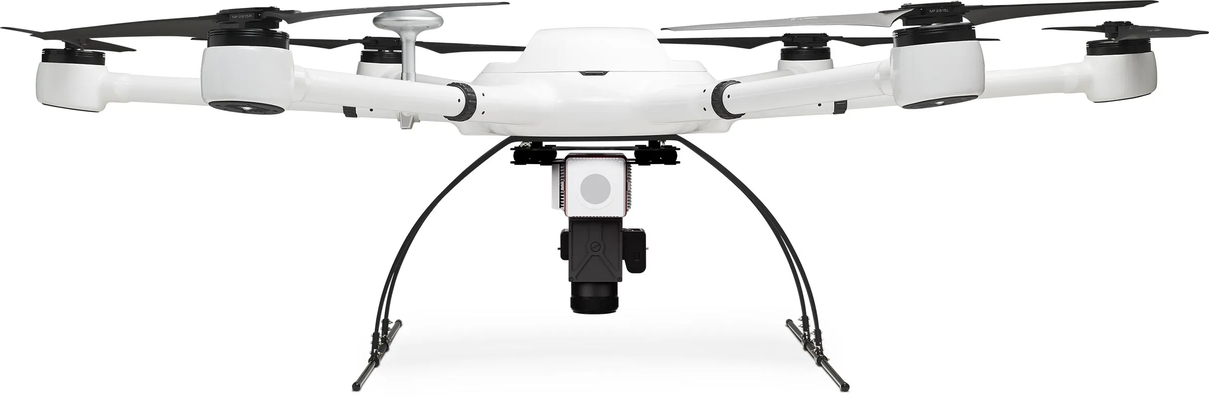
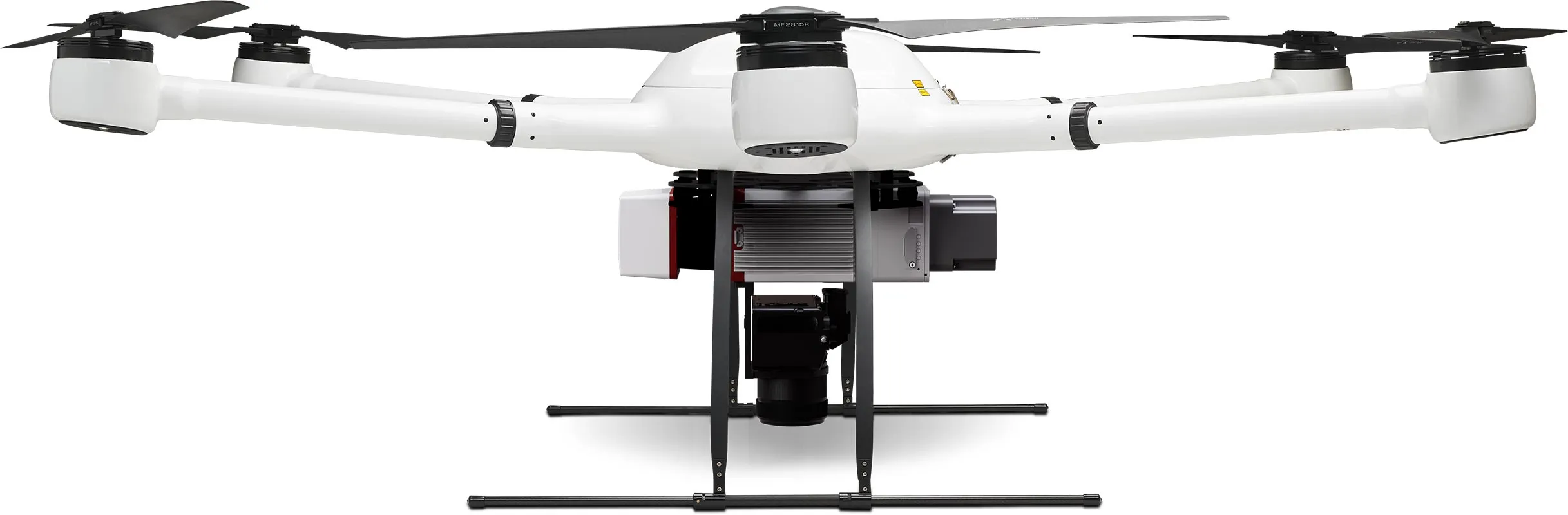
Icon: Weight
13 kg
max payload
Icon: Width
200 cm
Span
Icon: Photo and magnifying glass
< 1 cm
Accuracy
Icon: LiDAR scan range
500 m
LiDAR range
Atlas LiDAR

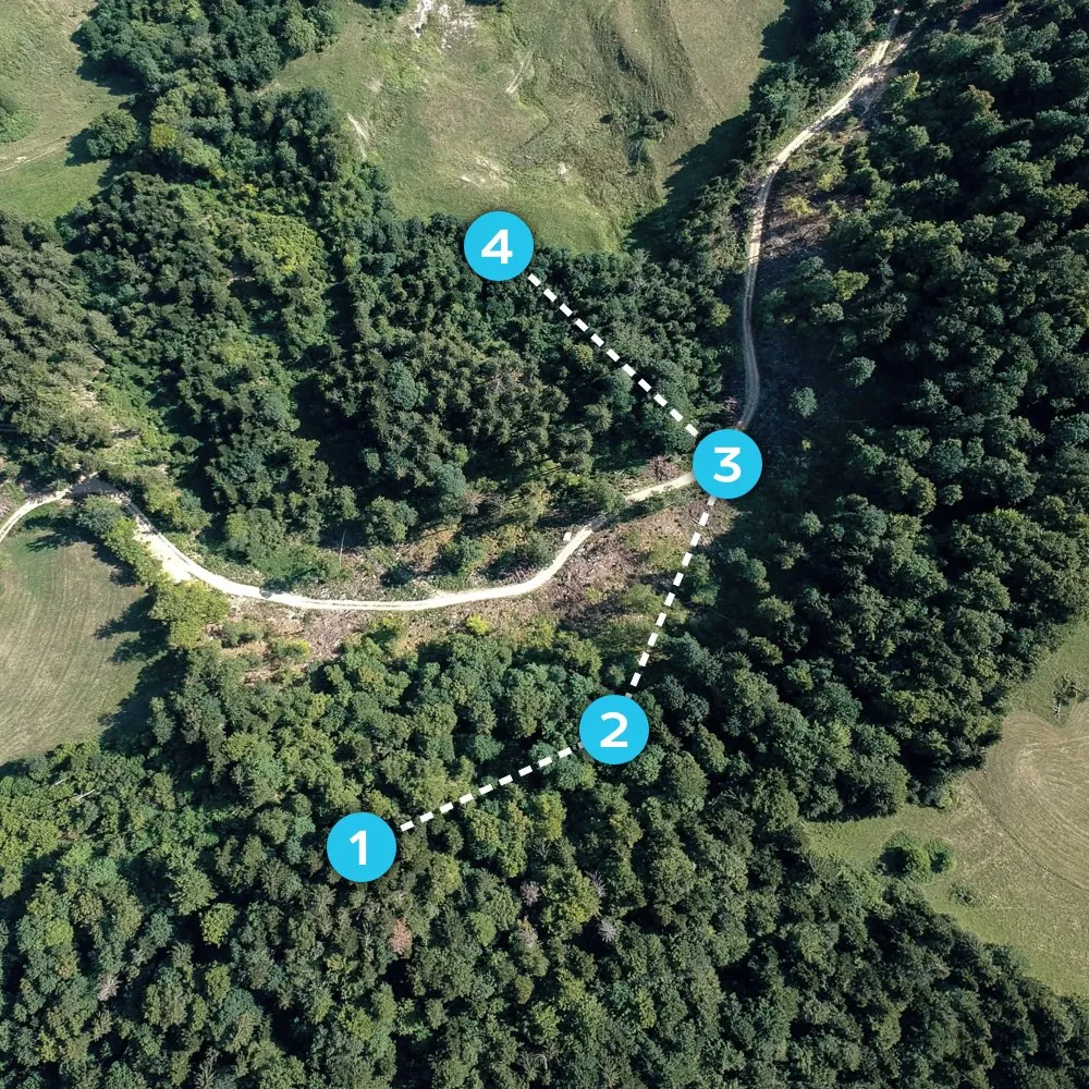
Much area in a short time with high accuracy

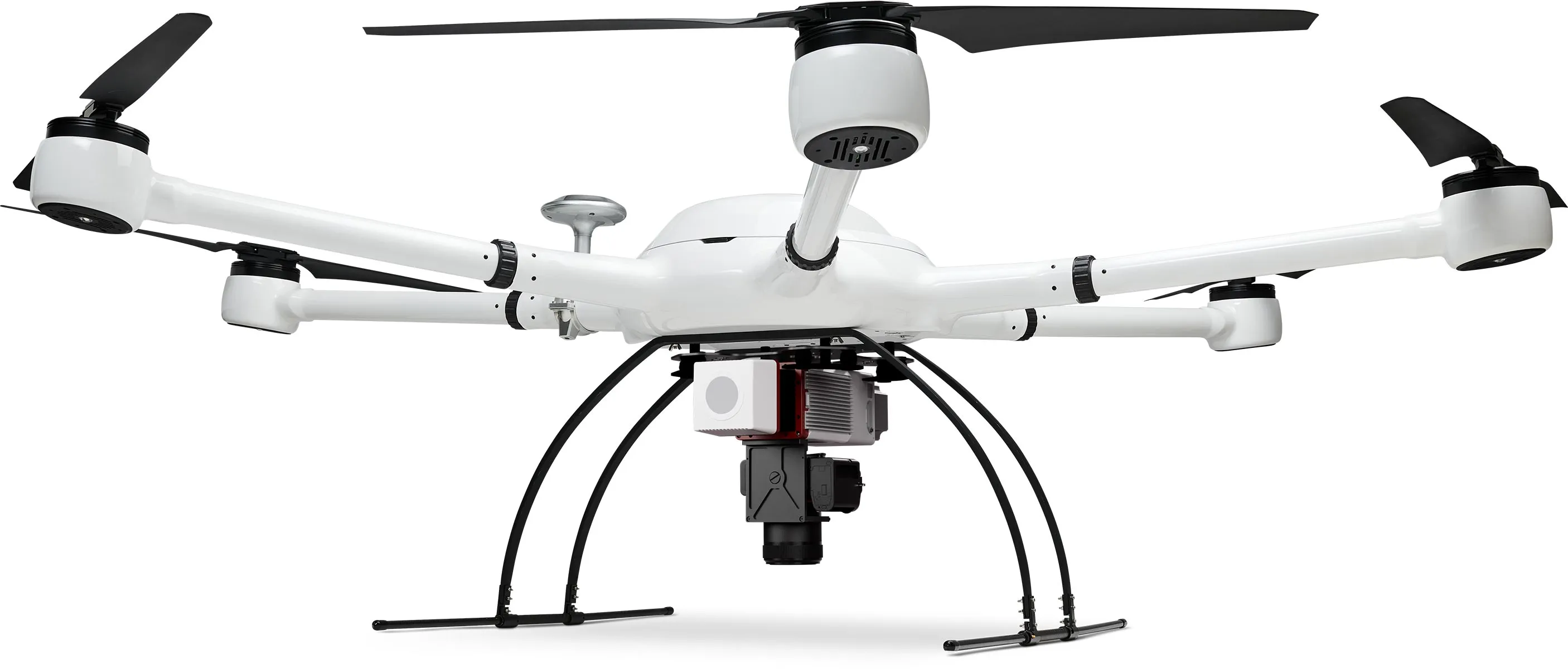
The scanner from the Atlas LiDAR package offers a very high accuracy of 1 cm and provides high quality color images thanks to the integrated 24 MP camera, so that captured LIDAR data and photos can be combined to colorized point clouds. Despite vegetation, the scanner can capture the ground surface This package gives you everything you need for professional results of the highest quality.

Efficient. Accurate. Fast.

Thanks to its 360° field of view, the Atlas LiDAR scans a very large area in a short time while offering very high accuracy in locating the captured data. Depending on the weather conditions, the drone with its two batteries can stay in the air for up to 25 minutes and operate at flight altitudes of up to 5,000 meters above sea level. This surveying solution leaves nothing to be desired.

Icon: Stopwatch
25 min
Flight time
5000 m
Flight altitude
Vast landscape, through which a path winds, in the sunset.

Simple and intuitive flight planning

Flight planning made easy: Set the framework for your survey project on your PC or on the remote control screen and your drone will perform the flight automatically. If desired, you can intervene in the control via the EB controllers and steer by hand.

Icon: Waypoint for mission planning
PC+RC
Flight planning
Icon: automated drone flight
AutoFlight
Automatic missions
Aerial view of a forest area with waypoints for automated drone flight.

Handy and robust remote control

With the portable EB controller with a high-resolution 5.5 inch monitor, you always have full flight control. A range of up to 4 kilometers gives you plenty of scope, just like the built-in 4950 mAh lithium polymer battery for up to 5 hours of runtime.

Icon: Display size
5.5 inch
RC display
Icon: Battery being charged
5 h
Battery life
Exabotix employee controls drone in the distance over a pipeline running through an uninhabited landscape.

LiPo power for enduring missions

Two powerful flight batteries provide good endurance and excellent flight performance. With 22,000 mAh and 22.2 volts, they are real power packs. The batteries are located inside, so they are protected from the weather, can be replaced in a few simple steps and are fully recharged in just 45 minutes.

Icon: Battery, three quarters full
22K
mAh capacity
Icon: Stopwatch
45 min
Loading time
Exabotix Atlas drone with heavy gas sensor during an inspection flight over an area covered with a tarp in a wooded area.

For which applications is this package suitable?

Do you want to image large areas with the highest accuracy? This package shines with a very powerful scanner in combination with an excellent camera. The measuring points are located with high precision thanks to the multiband RTK-GNSS receiver - the best prerequisites for demanding cartography tasks.

Exabotix Atlas LiDAR Industrial drone front view with combined LiDAR scanner and camera for accurate true color 3D scanning and mapping tasks.

Surveying

Cartography

Corridor mapping

Mining

Structural and civil engineering

Volume calculation

Atlas LiDAR Components

Icon: Hexacopter
Hexacopter
The Atlas drone has six drive units and a very sturdy housing. The drone is compactly stowable for transport, its separate arms are simply plugged in, so it is quickly ready for use. With up to 13 kg payload, it offers enough capacity even for quite heavy payloads.
Icon: Battery, three quarters full
Battery
Two powerful LiPo flight batteries with 22,000 mAh each provide plenty of power for enduring missions. The batteries can be replaced in just a few steps, so even extensive surveying projects can be carried out without any problems.
Icon: Battery being charged
Charger
This fast charger lives up to its name: Two batteries can be fully charged simultaneously within 45 minutes.
Icon: Transport box
Transport box
In the robust and impact-resistant transport box, the drone system is well protected and practical to transport at any time.
LiDAR scanner
Riegl's 200,000 p/sec miniVUX-3UAV scanning unit provides up to 1 cm accuracy at a maximum flight altitude of 100 meters, supported by a proprietary GNSS and IMU unit from Applanix. Perfect for tasks where even the smallest details need to be captured.
Icon: Iris diaphragm
Camera
The Sony A6000 is a perfect solution thanks to its outstanding speed, high resolution with 24 MP and professional operation, which reliably produces good results even under the most difficult conditions.
Icon: two circular arrows rotating counterclockwise around a circle.
Postprocessing
The post-processing software is part of the Exabotix performance package and allows to convert the raw data from the scanner into different point cloud data formats as well as to perform colorization based on the camera RGB data.
RTK multiband
The system achieves very high accuracy: via a multiband RTK-GNSS receiver, the collected position data is corrected and provides high precision with deviations in the millimeter range.
Remote control
The portable EB controller has a large display and enables intuitive route planning and operation via touchscreen and also has physical controls for hand control. The robust workmanship and its long battery life make the EB Controller a reliable work tool.

Cost?

This package is a real price-performance miracle: long flight time, powerful scanner and intuitive project planning as well as easy further processing of the highly accurate data. The Atlas LiDAR is your professional surveying tool. We will be happy to explain the advantages of this package to you individually - just contact us.